
Thank you for supporting this site ❤️
Make a donation
Make a donation
Lady Grey topographic map
Click on the map to display elevation.
Thank you for supporting this site ❤️
Make a donation
Make a donation
About this map
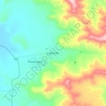
Name: Lady Grey topographic map, elevation, terrain.
Average elevation: 1,803 m
Minimum elevation: 1,549 m
Maximum elevation: 2,348 m
Thank you for supporting this site ❤️
Make a donation
Make a donation
Other topographic maps
Click on a map to view its topography, its elevation and its terrain.
Sterkspruit
South Africa > Eastern Cape > Joe Gqabi District Municipality > Senqu Local Municipality
Average elevation: 2,026 m