
Hooper topographic map
Interactive map
Click on the map to display elevation.
About this map
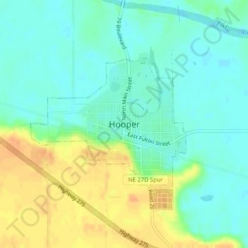
Name: Hooper topographic map, elevation, terrain.
Location: Hooper, Dodge County, Nebraska, United States (41.60454 -96.56134 41.61887 -96.53871)
Average elevation: 381 m
Minimum elevation: 368 m
Maximum elevation: 402 m
Other topographic maps
Click on a map to view its topography, its elevation and its terrain.
North Bend
United States > Nebraska > Dodge County
North Bend, Dodge County, Nebraska, United States
Average elevation: 388 m
Winslow
United States > Nebraska > Dodge County
Winslow, Dodge County, Nebraska, 68072, United States
Average elevation: 374 m
Fremont
United States > Nebraska > Dodge County
Fremont, Dodge County, Nebraska, 68025, United States
Average elevation: 365 m