
Havel topographic map
Interactive map
Click on the map to display elevation.
About this map
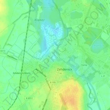
Name: Havel topographic map, elevation, terrain.
Location: Havel, Zehdenick, Oberhavel, Brandenburg, 16792, Deutschland (52.98201 13.33053 52.98395 13.33157)
Average elevation: 48 m
Minimum elevation: 36 m
Maximum elevation: 64 m
Other topographic maps
Click on a map to view its topography, its elevation and its terrain.
Kamp
Deutschland > Brandenburg > Oberhavel > Zehdenick
Kamp, Zehdenick, Oberhavel, Brandenburg, 16792, Deutschland
Average elevation: 48 m
Osterne
Deutschland > Brandenburg > Oberhavel > Zehdenick
Osterne, Badingen, Zehdenick, Oberhavel, Brandenburg, Deutschland
Average elevation: 62 m