
Make a donation
Calabarzon topographic map
Click on the map to display elevation.
Make a donation
About this map
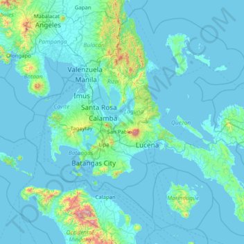
Name: Calabarzon topographic map, elevation, terrain.
Location: Calabarzon, Philippines (13.02503 120.34558 15.30225 122.86442)
Average elevation: 99 m
Minimum elevation: -2 m
Maximum elevation: 2,505 m
Make a donation
Other topographic maps
Click on a map to view its topography, its elevation and its terrain.
Antipolo
Its higher elevation than that of Metro Manila affords it a scenic view of the metropolis, especially at night. Its locally grown mangoes and cashews are popular among tourists, as well as suman – a local delicacy made out of glutinous rice. The Hinulugang Taktak National Park, which was once a popular…
Average elevation: 125 m
Make a donation
Make a donation
Make a donation
Make a donation
Make a donation
Muntinlupa
There are three plausible origins of the name of the city: First, is its association with the thin topsoil in the area; second, residents, purportedly replying to a question by Spaniards in the 16th century what the name of their place was, said “Monte sa Lupa”—apparently mistaking the question for what…
Average elevation: 41 m
Make a donation
Make a donation