
Dunmore East topographic map
Interactive map
Click on the map to display elevation.
About this map
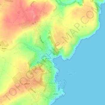
Name: Dunmore East topographic map, elevation, terrain.
Location: Dunmore East, County Waterford, Munster, X91 C677, Irland (52.14340 -7.01165 52.16995 -6.98898)
Average elevation: 36 m
Minimum elevation: 0 m
Maximum elevation: 84 m
Das Passage tomb von Harristown liegt an der Ostseite einer Anhöhe, die als "Carrick a Dhirra" bekannt ist, etwa 3,9 km von Dunmore East. Die Gründung der Stadt Dunmore East ist ungeklärt. 1640 ließ Lord Power of Curraghmore, der viele Besitztümer in der Gegend hatte, auf den Klippen oberhalb des kleinen Strandes des Dorfes ein Schloss bauen. In der Mitte des darauffolgenden Jahrhunderts verfiel das Schloss jedoch, so dass heute von den Ruinen nur noch ein Turm erhalten ist.
Other topographic maps
Click on a map to view its topography, its elevation and its terrain.
Bridgetown
Bridgetown, Clonea, The Municipal District of Comeragh, County Waterford, Munster, Irland
Average elevation: 89 m
Waterford
Waterford, County Waterford, Munster, Irland
Average elevation: 33 m