
Ighil Igoulmimene topographic map
Interactive map
Click on the map to display elevation.
About this map
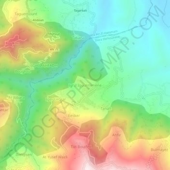
Name: Ighil Igoulmimene topographic map, elevation, terrain.
Average elevation: 598 m
Minimum elevation: 275 m
Maximum elevation: 1,122 m
Other topographic maps
Click on a map to view its topography, its elevation and its terrain.
Imsouhal
Algérie > Tizi Ouzou > Daïra Iferhounene > Imsouhal
Imsouhal, Daïra Iferhounene, Tizi Ouzou, 15024, Algérie
Average elevation: 661 m
Esker
Algérie > Tizi Ouzou > Daïra Iferhounene > Imsouhal
Esker, Imsouhal, Daïra Iferhounene, Tizi Ouzou, 15024, Algérie
Average elevation: 701 m