
Make a donation
Paarl topographic map
Click on the map to display elevation.
Make a donation
About this map
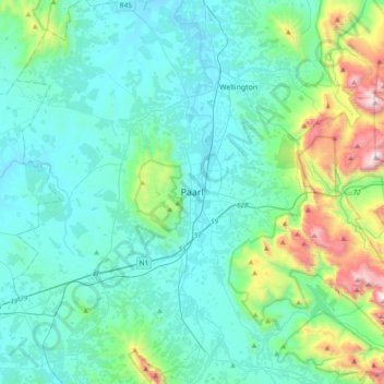
Name: Paarl topographic map, elevation, terrain.
Average elevation: 358 m
Minimum elevation: 78 m
Maximum elevation: 1,740 m
Make a donation
Other topographic maps
Click on a map to view its topography, its elevation and its terrain.
Stellenbosch
South Africa > Western Cape > Cape Winelands District Municipality > Stellenbosch Local Municipality
Stellenbosch is 53 km (33 mi) east of Cape Town via National Route N1. Stellenbosch is in a hilly region of the Cape Winelands, and is sheltered in a valley at an average elevation of 136 m (446 ft), flanked on the west by Papegaaiberg (Afrikaans: Parrot Mountain), which is actually a hill. To the south is…
Average elevation: 287 m
Langeberg Local Municipality
South Africa > Western Cape > Cape Winelands District Municipality
Average elevation: 589 m
Jonkershoek Nature Reserve
South Africa > Western Cape > Cape Winelands District Municipality > Stellenbosch Local Municipality
Average elevation: 522 m
Hex River
South Africa > Western Cape > Cape Winelands District Municipality > Breede Valley Local Municipality
Average elevation: 644 m
Make a donation
Stellenbosch Local Municipality
South Africa > Western Cape > Cape Winelands District Municipality
Average elevation: 431 m
Drakenstein Local Municipality
South Africa > Western Cape > Cape Winelands District Municipality
Average elevation: 397 m
Witzenberg Ward 9
South Africa > Western Cape > Cape Winelands District Municipality > Witzenberg Local Municipality
Average elevation: 892 m
Wemmershoek Dam
South Africa > Western Cape > Cape Winelands District Municipality > Paarl
Average elevation: 396 m
Make a donation
Breede Valley Local Municipality
South Africa > Western Cape > Cape Winelands District Municipality
Average elevation: 627 m
Eerste River
South Africa > Western Cape > Cape Winelands District Municipality > Stellenbosch Local Municipality > Stellenbosch
Average elevation: 104 m
Elands River
South Africa > Western Cape > Cape Winelands District Municipality > Drakenstein Local Municipality
Average elevation: 1,043 m
Breede River
South Africa > Western Cape > Cape Winelands District Municipality > Breede Valley Local Municipality
Average elevation: 219 m
Make a donation
Stellenbosch
South Africa > Western Cape > Cape Winelands District Municipality > Stellenbosch Local Municipality
Stellenbosch is 53 km (33 mi) east of Cape Town via National Route N1. Stellenbosch is in a hilly region of the Cape Winelands, and is sheltered in a valley at an average elevation of 136 m (446 ft), flanked on the west by Papegaaiberg (Afrikaans: Parrot Mountain), which is actually a hill. To the south is…
Average elevation: 287 m
Stellenbosch Local Municipality
South Africa > Western Cape > Cape Winelands District Municipality
Average elevation: 431 m
Stellenbosch Local Municipality
South Africa > Western Cape > Cape Winelands District Municipality
Average elevation: 431 m
Make a donation
Tankwa Town
South Africa > Western Cape > Cape Winelands District Municipality > Witzenberg Local Municipality
Average elevation: 477 m
Langeberg Local Municipality
South Africa > Western Cape > Cape Winelands District Municipality
Average elevation: 589 m
Eerste River
South Africa > Western Cape > Cape Winelands District Municipality > Stellenbosch Local Municipality
Average elevation: 396 m
Berg River Dam
South Africa > Western Cape > Cape Winelands District Municipality > Stellenbosch Local Municipality
Average elevation: 376 m
Make a donation
Stellenbosch
South Africa > Western Cape > Cape Winelands District Municipality > Stellenbosch Local Municipality
Stellenbosch is 53 km (33 mi) east of Cape Town via National Route N1. Stellenbosch is in a hilly region of the Cape Winelands, and is sheltered in a valley at an average elevation of 136 m (446 ft), flanked on the west by Papegaaiberg (Afrikaans: Parrot Mountain), which is actually a hill. To the south is…
Average elevation: 287 m