
Thank you for supporting this site ❤️
Make a donation
Make a donation
Nittenau topographic map
Click on the map to display elevation.
Thank you for supporting this site ❤️
Make a donation
Make a donation
About this map
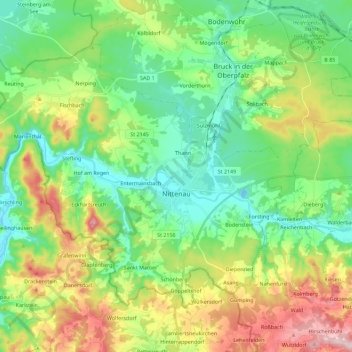
Name: Nittenau topographic map, elevation, terrain.
Location: Nittenau, Landkreis Schwandorf, Bavaria, 93149, Germany (49.14958 12.13746 49.26145 12.36376)
Average elevation: 432 m
Minimum elevation: 335 m
Maximum elevation: 630 m
Thank you for supporting this site ❤️
Make a donation
Make a donation
Other topographic maps
Click on a map to view its topography, its elevation and its terrain.
Bruck in der Oberpfalz
Germany > Bavaria > Landkreis Schwandorf > Bruck i.d.OPf.
Average elevation: 404 m