
Ewaso Ngiro River topographic map
Interactive map
Click on the map to display elevation.
About this map
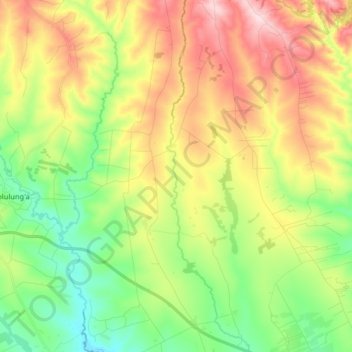
Name: Ewaso Ngiro River topographic map, elevation, terrain.
Location: Ewaso Ngiro River, Narok, Kenya (-1.07383 35.73579 -0.91192 35.77372)
Average elevation: 2,012 m
Minimum elevation: 1,887 m
Maximum elevation: 2,188 m
Other topographic maps
Click on a map to view its topography, its elevation and its terrain.
Masai Mara National Reserve
Masai Mara National Reserve, Narok, Kenya
Average elevation: 1,640 m
Serengeti National Park
Serengeti National Park, C12, Narok, Kenya
Average elevation: 1,852 m