
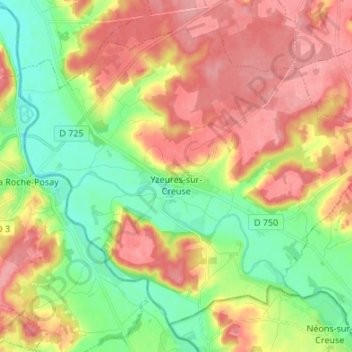
Yzeures-sur-Creuse topographic map
Interactive map
Click on the map to display elevation.
About this map
Name: Yzeures-sur-Creuse topographic map, elevation, terrain.
Average elevation: 95 m
Minimum elevation: 51 m
Maximum elevation: 139 m
La confluence est marquée visuellement par une butte boisée qui partage les deux vallées et constitue un élément topographique majeur au cœur du territoire communal.
Other topographic maps
Click on a map to view its topography, its elevation and its terrain.
Cheillé
France > Centre-Val de Loire > Indre-et-Loire
Cheillé, Tours, Indre-et-Loire, Centre-Val de Loire, France métropolitaine, 37190, France
Average elevation: 91 m
Descartes
France > Centre-Val de Loire > Indre-et-Loire
Descartes, Loches, Indre-et-Loire, Centre-Val de Loire, France métropolitaine, 37160, France
Average elevation: 90 m
Le Liège
France > Centre-Val de Loire > Indre-et-Loire
Le Liège, Loches, Indre-et-Loire, Centre-Val de Loire, France métropolitaine, 37460, France
Average elevation: 119 m
Tours
France > Centre-Val de Loire > Indre-et-Loire
Tours, Indre-et-Loire, Centre-Val de Loire, France métropolitaine, France
Average elevation: 73 m
Luzillé
France > Centre-Val de Loire > Indre-et-Loire
Luzillé, Loches, Indre-et-Loire, Centre-Val de Loire, France métropolitaine, 37150, France
Average elevation: 106 m
Draché
France > Centre-Val de Loire > Indre-et-Loire
Draché, Loches, Indre-et-Loire, Centre-Val de Loire, France métropolitaine, 37800, France
Average elevation: 85 m
La Ville
France > Centre-Val de Loire > Indre-et-Loire > Sainte-Maure-de-Touraine
La Ville, Sainte-Maure-de-Touraine, Chinon, Indre-et-Loire, Centre-Val de Loire, France métropolitaine, 37800, France
Average elevation: 97 m
Château
France > Centre-Val de Loire > Indre-et-Loire > Sainte-Maure-de-Touraine > La Ville
Château, Rue du Château, La Ville, Sainte-Maure-de-Touraine, Chinon, Indre-et-Loire, Centre-Val de Loire, France métropolitaine, 37800, France
Average elevation: 92 m
Les Évées
France > Centre-Val de Loire > Indre-et-Loire > Saint-Martin-le-Beau
Les Évées, Saint-Martin-le-Beau, Loches, Indre-et-Loire, Centre-Val de Loire, France métropolitaine, 37270, France
Average elevation: 71 m
Courçay
France > Centre-Val de Loire > Indre-et-Loire
Courçay, Loches, Indre-et-Loire, Centre-Val de Loire, France métropolitaine, 37310, France
Average elevation: 87 m
Monts
France > Centre-Val de Loire > Indre-et-Loire
Monts, Tours, Indre-et-Loire, Centre-Val de Loire, France métropolitaine, 37260, France
Average elevation: 81 m
Saint-Pierre-des-Corps
France > Centre-Val de Loire > Indre-et-Loire
Saint-Pierre-des-Corps, Arrondissement de Tours, Indre-et-Loire, Centre-Val de Loire, France métropolitaine, 37700, France
Average elevation: 55 m
Tours
France > Centre-Val de Loire > Indre-et-Loire > Tours
Tours, Indre-et-Loire, Centre-Val de Loire, France métropolitaine, 37000, France
Average elevation: 91 m
Marolle
France > Centre-Val de Loire > Indre-et-Loire > Genillé
Marolle, Genillé, Loches, Indre-et-Loire, Centre-Val de Loire, France métropolitaine, 37460, France
Average elevation: 122 m
Les Quarts
France > Centre-Val de Loire > Indre-et-Loire > Montbazon
Les Quarts, Montbazon, Arrondissement de Tours, Indre-et-Loire, Centre-Val de Loire, France métropolitaine, 37250, France
Average elevation: 78 m
Tour Heurtault
France > Centre-Val de Loire > Indre-et-Loire > Amboise > La Ville-Sud
Tour Heurtault, Place Michel Debré, Quai du Maréchal Joffre, La Ville-Sud, Amboise, Loches, Indre-et-Loire, Centre-Val de Loire, France métropolitaine, 37400, France
Average elevation: 71 m
Cinais
France > Centre-Val de Loire > Indre-et-Loire > Cinais
Cinais, Chinon, Indre-et-Loire, Centre-Val de Loire, France métropolitaine, 37500, France
Average elevation: 49 m
Loches
France > Centre-Val de Loire > Indre-et-Loire
Loches, Indre-et-Loire, Centre-Val de Loire, France métropolitaine, 37600, France
Average elevation: 106 m
Richelieu
France > Centre-Val de Loire > Indre-et-Loire
Richelieu, Chinon, Indre-et-Loire, Centre-Val de Loire, France métropolitaine, 37120, France
Average elevation: 62 m
Langeais
France > Centre-Val de Loire > Indre-et-Loire > Langeais
Langeais, Chinon, Indre-et-Loire, Centre-Val de Loire, France métropolitaine, 37130, France
Average elevation: 82 m
Villaines-les-Rochers
France > Centre-Val de Loire > Indre-et-Loire
Villaines-les-Rochers, Arrondissement de Tours, Indre-et-Loire, Centre-Val de Loire, France métropolitaine, 37190, France
Average elevation: 97 m