
Thank you for supporting this site ❤️
Make a donation
Make a donation
West Hoathly topographic map
Click on the map to display elevation.
Thank you for supporting this site ❤️
Make a donation
Make a donation
About this map
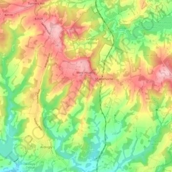
Name: West Hoathly topographic map, elevation, terrain.
Average elevation: 112 m
Minimum elevation: 38 m
Maximum elevation: 193 m
Thank you for supporting this site ❤️
Make a donation
Make a donation
Other topographic maps
Click on a map to view its topography, its elevation and its terrain.
Felbridge
United Kingdom > England > West Sussex > Mid Sussex > East Grinstead
Average elevation: 98 m
Thank you for supporting this site ❤️
Make a donation
Make a donation
Ardingly Reservoir
United Kingdom > England > West Sussex > Mid Sussex > Ardingly
Average elevation: 98 m
Henry Burt Wood
United Kingdom > England > West Sussex > Mid Sussex > Burgess Hill
Average elevation: 39 m
Worth Abbey
United Kingdom > England > West Sussex > Mid Sussex > Turners Hill
Average elevation: 124 m
Thank you for supporting this site ❤️
Make a donation
Make a donation
Thank you for supporting this site ❤️
Make a donation
Make a donation
Thank you for supporting this site ❤️
Make a donation
Make a donation
Twineham Green
United Kingdom > England > West Sussex > Mid Sussex > Hickstead > Twineham Green
Average elevation: 21 m
Thank you for supporting this site ❤️
Make a donation
Make a donation