
Java Occidental topographic map
Interactive map
Click on the map to display elevation.
About this map
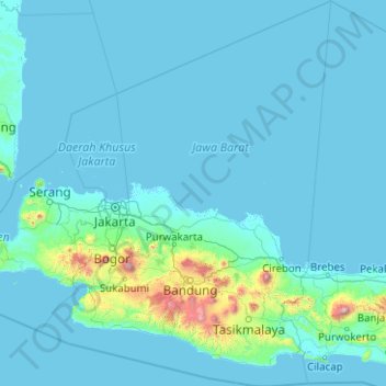
Name: Java Occidental topographic map, elevation, terrain.
Location: Java Occidental, Indonesia (-8.02075 106.05095 -4.03879 109.06979)
Average elevation: 103 m
Minimum elevation: -2 m
Maximum elevation: 3,327 m
Other topographic maps
Click on a map to view its topography, its elevation and its terrain.
Cinere
Indonesia > Java Occidental > Bogor
Cinere, Bogor, Java Occidental, Jawa, 16514, Indonesia
Average elevation: 57 m
Gandul
Indonesia > Java Occidental > Gandul
Gandul, Java Occidental, 16512, Indonesia
Average elevation: 62 m