
Canterbury topographic map
Interactive map
Click on the map to display elevation.
About this map
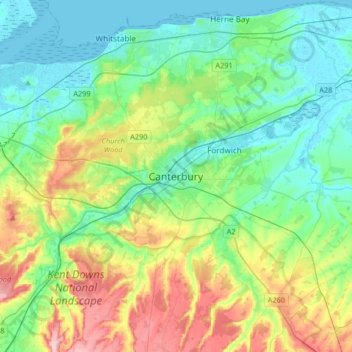
Name: Canterbury topographic map, elevation, terrain.
Location: Canterbury, Kent, England, Vereinigtes Königreich (51.17719 0.93720 51.38254 1.25007)
Average elevation: 51 m
Minimum elevation: -1 m
Maximum elevation: 178 m
Other topographic maps
Click on a map to view its topography, its elevation and its terrain.
Baobab
Vereinigtes Königreich > England > Kent > Canterbury > Harbledown
Baobab, Jessie’s bridge, St. Mildred's, Harbledown, Canterbury, Kent, England, CT2 8AA, Vereinigtes Königreich
Average elevation: 25 m