
Willie's Law topographic map
Interactive map
Click on the map to display elevation.
About this map
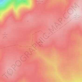
Name: Willie's Law topographic map, elevation, terrain.
Location: Willie's Law, Scottish Borders, Scotland, United Kingdom (55.83817 -2.69101 55.83827 -2.69091)
Average elevation: 472 m
Minimum elevation: 243 m
Maximum elevation: 533 m
Other topographic maps
Click on a map to view its topography, its elevation and its terrain.
Viewfield
United Kingdom > Scotland > Scottish Borders
Viewfield, Scottish Borders, Scotland, TD10 6UW, United Kingdom
Average elevation: 136 m
Hawick
United Kingdom > Scotland > Scottish Borders
Hawick, Scottish Borders, Scotland, TD9 9EG, United Kingdom
Average elevation: 199 m
Galashiels
United Kingdom > Scotland > Scottish Borders
Galashiels, Scottish Borders, Scotland, United Kingdom
Average elevation: 221 m
Eddleston
United Kingdom > Scotland > Scottish Borders
Eddleston, Scottish Borders, Scotland, EH45 8RE, United Kingdom
Average elevation: 282 m
Cavers
United Kingdom > Scotland > Scottish Borders > Cavers
Cavers, Scottish Borders, Scotland, TD9 8LJ, United Kingdom
Average elevation: 157 m