
Thank you for supporting this site ❤️
Make a donation
Make a donation
Asel topographic map
Click on the map to display elevation.
Thank you for supporting this site ❤️
Make a donation
Make a donation
About this map
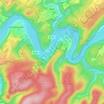
Name: Asel topographic map, elevation, terrain.
Location: Asel, Vöhl, Landkreis Waldeck-Frankenberg, Hessen, Duitsland (51.15064 8.92885 51.19963 8.97855)
Average elevation: 341 m
Minimum elevation: 239 m
Maximum elevation: 481 m
Thank you for supporting this site ❤️
Make a donation
Make a donation
Other topographic maps
Click on a map to view its topography, its elevation and its terrain.
Thank you for supporting this site ❤️
Make a donation
Make a donation
Rothaargebirge
Duitsland > Hessen > Landkreis Waldeck-Frankenberg > Willingen
Average elevation: 727 m