
Le Clou topographic map
Interactive map
Click on the map to display elevation.
About this map
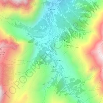
Name: Le Clou topographic map, elevation, terrain.
Location: Le Clou, La Fouly, Orsières, Entremont, Valais, 2303, Suisse (45.90609 7.07717 45.94609 7.11717)
Average elevation: 2,009 m
Minimum elevation: 1,509 m
Maximum elevation: 2,796 m
Other topographic maps
Click on a map to view its topography, its elevation and its terrain.
Les Granges
Suisse > Valais > Entremont > La Fouly
Les Granges, La Fouly, Orsières, Entremont, Valais, 2303, Suisse
Average elevation: 2,026 m
Gîte de la Léchère
Suisse > Valais > Entremont > La Fouly > Les Granges
Gîte de la Léchère, 2, Les Granges, La Fouly, Orsières, Entremont, Valais, 1944, Suisse
Average elevation: 1,899 m