
South Andaman topographic map
Interactive map
Click on the map to display elevation.
About this map
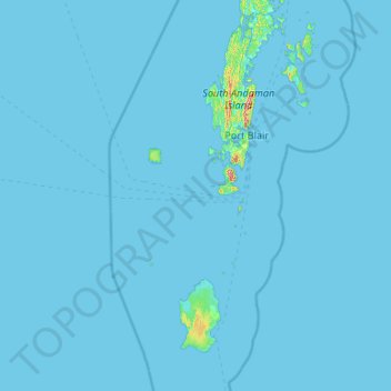
Name: South Andaman topographic map, elevation, terrain.
Location: South Andaman, Andaman and Nicobar Islands, India (10.30550 91.99180 12.37939 93.32719)
Average elevation: 3 m
Minimum elevation: -1 m
Maximum elevation: 413 m
Other topographic maps
Click on a map to view its topography, its elevation and its terrain.
Car Nicobar
India > Andaman and Nicobar Islands
Car Nicobar, Nicobar District, Andaman and Nicobar Islands, India
Average elevation: 11 m
Nicobar Islands
India > Andaman and Nicobar Islands > Great Nicobar
Nicobar Islands, Great Nicobar, Nicobar, Andaman and Nicobar Islands, India
Average elevation: 2 m
Port Blair
India > Andaman and Nicobar Islands > Port Blair
Port Blair, Andaman and Nicobar Islands, 744101, India
Average elevation: 14 m
Great Channel
India > Andaman and Nicobar Islands
Great Channel, Andaman and Nicobar Islands, India
Average elevation: 0 m
North and Middle Andaman
India > Andaman and Nicobar Islands
North and Middle Andaman, Andaman and Nicobar Islands, 744210, India
Average elevation: 4 m