
Olten topographic map
Interactive map
Click on the map to display elevation.
About this map
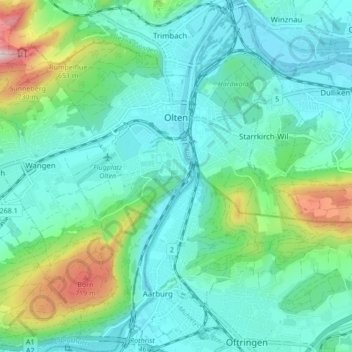
Name: Olten topographic map, elevation, terrain.
Location: Olten, Bezirk Olten, Amtei Olten-Gösgen, Solothurn, Schweiz (47.31103 7.87485 47.36892 7.92908)
Average elevation: 475 m
Minimum elevation: 381 m
Maximum elevation: 816 m
Other topographic maps
Click on a map to view its topography, its elevation and its terrain.
Boningen
Schweiz > Solothurn > Amtei Olten-Gösgen
Boningen, Bezirk Olten, Amtei Olten-Gösgen, Solothurn, 4618, Schweiz
Average elevation: 431 m
Wisen (SO)
Schweiz > Solothurn > Amtei Olten-Gösgen
Wisen (SO), Bezirk Gösgen, Amtei Olten-Gösgen, Solothurn, 4634, Schweiz
Average elevation: 761 m
Starrkirch-Wil
Schweiz > Solothurn > Amtei Olten-Gösgen > Starrkirch-Wil
Starrkirch-Wil, Bezirk Olten, Amtei Olten-Gösgen, Solothurn, 4656, Schweiz
Average elevation: 469 m