
Thank you for supporting this site ❤️
Make a donation
Make a donation
Kriskhevi topographic map
Click on the map to display elevation.
Thank you for supporting this site ❤️
Make a donation
Make a donation
About this map
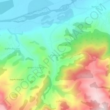
Name: Kriskhevi topographic map, elevation, terrain.
Location: Kriskhevi, Khashuri Municipality, Shida Kartli, Georgia (41.94574 43.63428 41.98574 43.67428)
Average elevation: 848 m
Minimum elevation: 676 m
Maximum elevation: 1,154 m
Thank you for supporting this site ❤️
Make a donation
Make a donation
Other topographic maps
Click on a map to view its topography, its elevation and its terrain.
Mtkvari
Georgia > Shida Kartli > Khashuri Municipality > Rbona
Most of the Kura runs in the broad and deep valley between the Greater Caucasus and Lesser Caucasus Mountains, and the major tributary, the Aras, drains most of the southern Caucasus and the mountain ranges of the extreme northern Middle East. The entirety of Armenia and most of Azerbaijan are drained by the…
Average elevation: 781 m