
珠穆朗玛峰/सगरमाथा topographic map
Interactive map
Click on the map to display elevation.
About this map
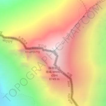
Name: 珠穆朗玛峰/सगरमाथा topographic map, elevation, terrain.
Average elevation: 7,839 m
Minimum elevation: 6,586 m
Maximum elevation: 8,849 m
Other topographic maps
Click on a map to view its topography, its elevation and its terrain.
Everest Camp de base
Everest Camp de base, Gorak Shep-Kala Patthar, गोरक शेप, Khumjung, Khumbupasanglahmu, सोलुखुम्बु, प्रदेश नं. १, 4, Népal
Average elevation: 5,425 m