
Thank you for supporting this site ❤️
Make a donation
Make a donation
Leamington topographic map
Click on the map to display elevation.
Thank you for supporting this site ❤️
Make a donation
Make a donation
About this map
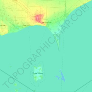
Name: Leamington topographic map, elevation, terrain.
Location: Leamington, Essex County, Ontario, Canada (41.67656 -82.67423 42.17162 -82.45790)
Average elevation: 177 m
Minimum elevation: 169 m
Maximum elevation: 230 m
Thank you for supporting this site ❤️
Make a donation
Make a donation
Other topographic maps
Click on a map to view its topography, its elevation and its terrain.
Thank you for supporting this site ❤️
Make a donation
Make a donation
Thank you for supporting this site ❤️
Make a donation
Make a donation
Thank you for supporting this site ❤️
Make a donation
Make a donation