
Thank you for supporting this site ❤️
Make a donation
Make a donation
Rostov Oblast topographic map
Click on the map to display elevation.
Thank you for supporting this site ❤️
Make a donation
Make a donation
About this map
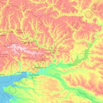
Name: Rostov Oblast topographic map, elevation, terrain.
Location: Rostov Oblast, Southern Federal District, Russia (45.95169 38.22089 50.21445 44.32415)
Average elevation: 102 m
Minimum elevation: -4 m
Maximum elevation: 359 m
Thank you for supporting this site ❤️
Make a donation
Make a donation
Other topographic maps
Click on a map to view its topography, its elevation and its terrain.
Thank you for supporting this site ❤️
Make a donation
Make a donation
Thank you for supporting this site ❤️
Make a donation
Make a donation
Thank you for supporting this site ❤️
Make a donation
Make a donation
Novoromanovka
Russia > Republic of Dagestan > Tarumovsky District > Novoromanovka
Average elevation: -8 m
Thank you for supporting this site ❤️
Make a donation
Make a donation
Thank you for supporting this site ❤️
Make a donation
Make a donation
Thank you for supporting this site ❤️
Make a donation
Make a donation