
Provincia de Flandes Oriental topographic map
Interactive map
Click on the map to display elevation.
About this map
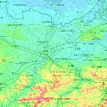
Name: Provincia de Flandes Oriental topographic map, elevation, terrain.
Location: Provincia de Flandes Oriental, Flandes, Bélgica (50.72101 3.33125 51.35397 4.33013)
Average elevation: 19 m
Minimum elevation: -4 m
Maximum elevation: 158 m
Other topographic maps
Click on a map to view its topography, its elevation and its terrain.
Grimbergen
Bélgica > Flandes > Grimbergen
Grimbergen, Halle-Vilvoorde, Brabante Flamenco, Flandes, Bélgica
Average elevation: 27 m