
Schruns topographic map
Interactive map
Click on the map to display elevation.
About this map
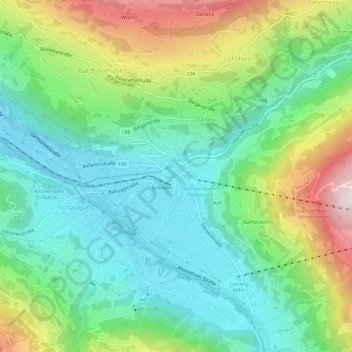
Name: Schruns topographic map, elevation, terrain.
Average elevation: 935 m
Minimum elevation: 647 m
Maximum elevation: 1,546 m
Other topographic maps
Click on a map to view its topography, its elevation and its terrain.
Gamplaschg
Autriche > Vorarlberg > Bezirk Bludenz > Marktgemeinde Schruns > Schruns
Gamplaschg, Schruns, Marktgemeinde Schruns, Bezirk Bludenz, Vorarlberg, 6780, Autriche
Average elevation: 1,036 m