
Latacunga topographic map
Interactive map
Click on the map to display elevation.
About this map
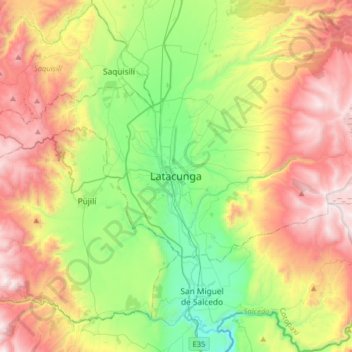
Name: Latacunga topographic map, elevation, terrain.
Location: Latacunga, Cotopaxi, 0501, Ecuador (-1.09403 -78.77458 -0.77403 -78.45458)
Average elevation: 3,213 m
Minimum elevation: 2,526 m
Maximum elevation: 4,165 m
Latacunga (ursprünglicher Name: San Vicente Mártir de la Tacunga y sus corregidores) ist eine Stadt im Andenhochland von Ecuador. Sie ist Hauptstadt der Provinz Cotopaxi und hat 96.355 Einwohner (2010). Latacunga liegt 89 km südlich von Quito auf 2760 m Höhe an der Panamericana und ist Sitz des Bistums Latacunga.