
Thank you for supporting this site ❤️
Make a donation
Make a donation
Canaan topographic map
Click on the map to display elevation.
Thank you for supporting this site ❤️
Make a donation
Make a donation
About this map
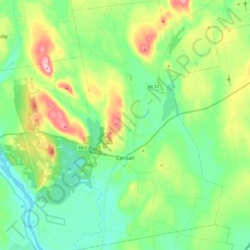
Name: Canaan topographic map, elevation, terrain.
Location: Canaan, Somerset County, Maine, 04924, United States (44.70463 -69.60747 44.85920 -69.47665)
Average elevation: 101 m
Minimum elevation: 30 m
Maximum elevation: 259 m
Thank you for supporting this site ❤️
Make a donation
Make a donation
Other topographic maps
Click on a map to view its topography, its elevation and its terrain.
No Name Pond
United States > Maine > Somerset County > Bald Mountain Township T4 R3
Average elevation: 686 m
Thank you for supporting this site ❤️
Make a donation
Make a donation