
Budenbach topographic map
Interactive map
Click on the map to display elevation.
About this map
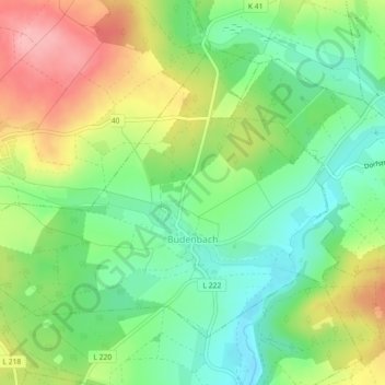
Name: Budenbach topographic map, elevation, terrain.
Average elevation: 414 m
Minimum elevation: 363 m
Maximum elevation: 486 m
Other topographic maps
Click on a map to view its topography, its elevation and its terrain.
Tiefenbach
Allemagne > Rhénanie-Palatinat > Rhein-Hunsrück-Kreis
Tiefenbach, Simmern-Rheinböllen, Rhein-Hunsrück-Kreis, Rhénanie-Palatinat, Allemagne
Average elevation: 418 m
Belg
Allemagne > Rhénanie-Palatinat > Rhein-Hunsrück-Kreis
Belg, Kirchberg (Hunsrück), Rhein-Hunsrück-Kreis, Rhénanie-Palatinat, Allemagne
Average elevation: 426 m