
Ongole topographic map
Click on the map to display elevation.
About this map
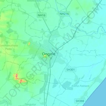
Name: Ongole topographic map, elevation, terrain.
Location: Ongole, Prakasam, Andhra Pradesh, India (15.43567 79.97218 15.57935 80.23082)
Average elevation: 13 m
Minimum elevation: 0 m
Maximum elevation: 137 m
Other topographic maps
Click on a map to view its topography, its elevation and its terrain.
Nellore
India > Andhra Pradesh > Nellore
Nellore is located at 14°26′N 79°59′E / 14.44°N 79.98°E / 14.44; 79.98. It has an average elevation of 18 metres (59 ft).
Average elevation: 17 m
Sullurpeta
India > Andhra Pradesh > Sullurpeta
Sullurupeta is located about 77 km east of Tirupati, 90 km south of Nellore and about 83 km north of Chennai, Tamilnadu. It is 16 km west of the world-famous ISRO island Sriharikota, where the Indian rockets are launched. The Pulicat lake separates Sullurpeta and Sriharikota. It has an average elevation of 11…
Average elevation: 4 m
Guntur
India > Andhra Pradesh > Guntur
Guntur is located at 16°17′N 80°26′E / 16.29°N 80.43°E / 16.29; 80.43. It has an average elevation of 33 metres (108 ft) and is situated on the plains. There are few hills in the surrounding suburban areas and Perecherla Reserve Forest is located in the city's north-west. Guntur lies…
Average elevation: 29 m
Visakhapatnam
India > Andhra Pradesh > Visakhapatnam (Urban)
The city is situated between the Eastern Ghats and the Bay of Bengal. The city coordinates lies between 17.7041 N and 83.2977 E. The city's area is 682 km2. The average elevation is 45 metres. Visakhpatnam is situated in Coastal Andhra Region.
Average elevation: 35 m
Vijayawada
Vijayawada lies on the banks of Krishna river, covered by hills and canals. and at an altitude of 11 m (36 ft) above sea level. Three canals originating from the north side of the Prakasam Barrage reservoir — Eluru, Bandar, and Ryves — flow through the city.
Average elevation: 37 m