
Nongstoin topographic map
Interactive map
Click on the map to display elevation.
About this map
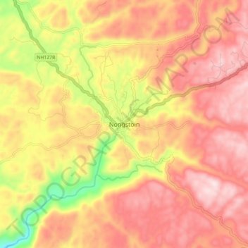
Name: Nongstoin topographic map, elevation, terrain.
Location: Nongstoin, West Khasi Hills District, Meghalaya, 793119, India (25.47939 91.22775 25.55939 91.30775)
Average elevation: 1,408 m
Minimum elevation: 1,119 m
Maximum elevation: 1,587 m
Nongstoin is located at 25°31′N 91°16′E / 25.52°N 91.27°E / 25.52; 91.27. It has an average elevation of 1409 metres (4622 feet).e