
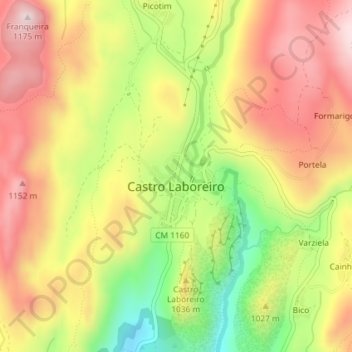
Castro Laboreiro topographic map
Interactive map
Click on the map to display elevation.
About this map
Name: Castro Laboreiro topographic map, elevation, terrain.
Average elevation: 994 m
Minimum elevation: 779 m
Maximum elevation: 1,167 m
Curral do Gonçalo, dans la paroisse de Castro Laboreiro, est situé à une altitude de 1 166 mètres, ce qui en fait le deuxième lieu habité le plus élevé du Portugal.
Other topographic maps
Click on a map to view its topography, its elevation and its terrain.
Castro Laboreiro
Portugal > Nord > Castro Laboreiro e Lamas de Mouro
Castro Laboreiro, Castro Laboreiro e Lamas de Mouro, Melgaço, Viana do Castelo, Alto Minho, Nord, 4960-095, Portugal
Average elevation: 943 m