
Thank you for supporting this site ❤️
Make a donation
Make a donation
Fox Den topographic map
Click on the map to display elevation.
Thank you for supporting this site ❤️
Make a donation
Make a donation
About this map
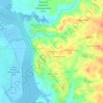
Name: Fox Den topographic map, elevation, terrain.
Location: Fox Den, Calvert County, Maryland, United States (38.59595 -76.68191 38.63595 -76.64191)
Average elevation: 18 m
Minimum elevation: -3 m
Maximum elevation: 48 m
Thank you for supporting this site ❤️
Make a donation
Make a donation
Other topographic maps
Click on a map to view its topography, its elevation and its terrain.
Thank you for supporting this site ❤️
Make a donation
Make a donation
Thank you for supporting this site ❤️
Make a donation
Make a donation