
Thank you for supporting this site ❤️
Make a donation
Make a donation
Mzinti topographic map
Click on the map to display elevation.
Thank you for supporting this site ❤️
Make a donation
Make a donation
About this map
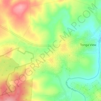
Name: Mzinti topographic map, elevation, terrain.
Average elevation: 255 m
Minimum elevation: 209 m
Maximum elevation: 312 m
Thank you for supporting this site ❤️
Make a donation
Make a donation
Other topographic maps
Click on a map to view its topography, its elevation and its terrain.
Lower Sabie Rest Camp
South Africa > Mpumalanga > Ehlanzeni District Municipality > Nkomazi
Average elevation: 181 m