
Clarke County topographic map
Interactive map
Click on the map to display elevation.
About this map
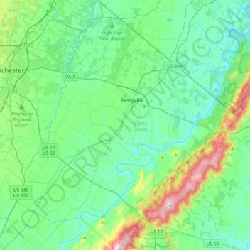
Name: Clarke County topographic map, elevation, terrain.
Location: Clarke County, Virginia, USA (38.98190 -78.15151 39.26440 -77.82804)
Average elevation: 200 m
Minimum elevation: 100 m
Maximum elevation: 581 m
Other topographic maps
Click on a map to view its topography, its elevation and its terrain.
James River
James River, Henrico County, Virginia, 23219:23223, USA
Average elevation: 89 m
Mount Hermon
USA > Virginia > Mount Hermon
Mount Hermon, Pittsylvania County, Virginia, USA
Average elevation: 199 m