
Cien Pesos topographic map
Interactive map
Click on the map to display elevation.
About this map
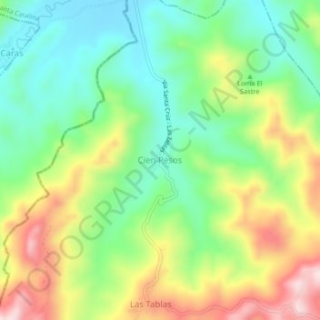
Name: Cien Pesos topographic map, elevation, terrain.
Location: Cien Pesos, Repelón, Atlántico, RAP Caribe, Colombia (10.51810 -75.24011 10.55810 -75.20011)
Average elevation: 219 m
Minimum elevation: 83 m
Maximum elevation: 431 m
Other topographic maps
Click on a map to view its topography, its elevation and its terrain.
Arroyo Negro
Colombia > Atlántico > Repelón
Arroyo Negro, Repelón, Atlántico, RAP Caribe, Colombia
Average elevation: 185 m