
Simmerath topographic map
Interactive map
Click on the map to display elevation.
About this map
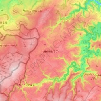
Name: Simmerath topographic map, elevation, terrain.
Average elevation: 482 m
Minimum elevation: 215 m
Maximum elevation: 666 m
Other topographic maps
Click on a map to view its topography, its elevation and its terrain.
Stolberg
Deutschland > Nordrhein-Westfalen > Städteregion Aachen > Stolberg
Stolberg, Städteregion Aachen, Nordrhein-Westfalen, Deutschland
Average elevation: 266 m
Dorff
Deutschland > Nordrhein-Westfalen > Städteregion Aachen > Stolberg > Dorff
Dorff, Stolberg, Städteregion Aachen, Nordrhein-Westfalen, 52223, Deutschland
Average elevation: 254 m