
Launceston topographic map
Interactive map
Click on the map to display elevation.
About this map
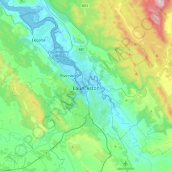
Name: Launceston topographic map, elevation, terrain.
Location: Launceston, City of Launceston, Tasmania, Australia (-41.52687 146.97218 -41.33457 147.30525)
Average elevation: 194 m
Minimum elevation: -3 m
Maximum elevation: 855 m
Launceston is at 41°26′31″S 147°8′42″E / 41.44194°S 147.14500°E / -41.44194; 147.14500 in the Tamar Valley, Northern Tasmania. The valley was formed by volcanic and glacial forces over 10 million years ago. The city is about 45 kilometres (28 mi) south of the Bass Strait, with its closest neighbour-city being Devonport, about 99 kilometres (62 mi) to the north west. Launceston combines steep (originally heavily wooded) ridges and low-lying areas (originally wetlands – with parts of the suburbs of Inveresk and Invermay below high-tide level). As a result, areas of Launceston are subject to landslip problems, while others are liable to poor drainage and periodic flooding. The topography of the area is not conducive to easy dispersion of airborne pollution, due to the phenomenon of thermal inversion.
Other topographic maps
Click on a map to view its topography, its elevation and its terrain.
Jackeys Marsh
Jackeys Marsh, Meander Valley, Tasmania, 7304, Australia
Average elevation: 760 m
Goulds Country
Goulds Country, Break O'Day, Tasmania, 7216, Australia
Average elevation: 308 m
Lake Belton
Lake Belton, Derwent Valley, Tasmania, Australia
Average elevation: 1,056 m
Vale of Belvoir Conservation Area
Vale of Belvoir Conservation Area, Kentish, Tasmania, Australia
Average elevation: 866 m
Erith Island
Erith Island, Flinders Council, Tasmania, Australia
Average elevation: 23 m
Chicken Island
Chicken Island, Huon Valley, Tasmania, Australia
Average elevation: 4 m
West Hobart
West Hobart, Hobart, City of Hobart, Tasmania, 7000, Australia
Average elevation: 105 m
Mount Nelson
Mount Nelson, Hobart, City of Hobart, Tasmania, 7007, Australia
Average elevation: 198 m
Lake Pedder
Australia > Tasmania > Strathgordon
Lake Pedder, Strathgordon, Derwent Valley, Tasmania, Australia
Average elevation: 366 m
Mersey Forest
Mersey Forest, Meander Valley, Tasmania, Australia
Average elevation: 866 m
Port Arthur
Port Arthur, Tasman, Tasmania, 7182, Australia
Average elevation: 153 m
Highland Waters
Australia > Tasmania > London Lakes
Highland Waters, London Lakes, Central Highlands, Tasmania, Australia
Average elevation: 759 m
Bullock Hill
Bullock Hill, Grove, Huon Valley, Tasmania, Australia
Average elevation: 147 m
Flinders Island
Flinders Island, Tasmania, 7255, Australia
Average elevation: 20 m
Grey Mares Tail
Australia > Tasmania > St Marys
Grey Mares Tail, St Marys, Break O'Day, Tasmania, Australia
Average elevation: 349 m
Anderson Island
Anderson Island, Flinders Council, Tasmania, Australia
Average elevation: 4 m
Macquarie Island
Macquarie Island, Huon Valley, Tasmania, Australia
Average elevation: 20 m
Bruny Island
Australia > Tasmania > Alonnah
Bruny Island, Alonnah, Kingborough, Tasmania, Australia
Average elevation: 59 m