
Make a donation
Purnia topographic map
Click on the map to display elevation.
Make a donation
About this map
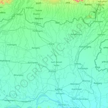
Name: Purnia topographic map, elevation, terrain.
Location: Purnia, Araria District, Bihar, India (25.30000 86.80000 26.70000 88.20000)
Average elevation: 54 m
Minimum elevation: 22 m
Maximum elevation: 612 m
Make a donation
Other topographic maps
Click on a map to view its topography, its elevation and its terrain.
Make a donation
East Champaran District
Raxaul is one of the most significant towns of the East Champaran district. By excellence of its topographical area, it is known as the Gateway to Nepal.
Average elevation: 70 m
Make a donation
Make a donation
Make a donation
Make a donation
Make a donation
Make a donation
Make a donation
Koshi River
The Kosi River catchment covers six geological and climatic belts varying in altitude from above 8,000 m (26,000 ft) to 95 m (312 ft) comprising the Tibetan plateau, the Himalayas, the Himalayan mid-hill belt, the Mahabharat Range, the Siwalik Hills and the Terai. The Dudh-Koshi sub-basin alone consists of 36…
Average elevation: 82 m
Make a donation
Make a donation
Make a donation