
George County topographic map
Interactive map
Click on the map to display elevation.
About this map
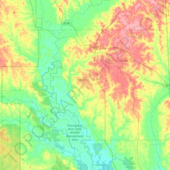
Name: George County topographic map, elevation, terrain.
Location: George County, Mississippi, United States (30.73427 -88.88499 30.99846 -88.41246)
Average elevation: 38 m
Minimum elevation: 0 m
Maximum elevation: 101 m
Other topographic maps
Click on a map to view its topography, its elevation and its terrain.
Cypress Creek Landing Recreation Site
United States > Mississippi > Perry County
Average elevation: 37 m
The Cotton District
United States > Mississippi > Oktibbeha County > Starkville
Average elevation: 106 m
Jack and Florence Goldin Sportsplex
United States > Mississippi > Harrison County > Gulfport
Average elevation: 13 m
Hickory Glen
United States > Mississippi > Rankin County > Pearl > Hickory Glen
Average elevation: 92 m