
Östringen topographic map
Interactive map
Click on the map to display elevation.
About this map
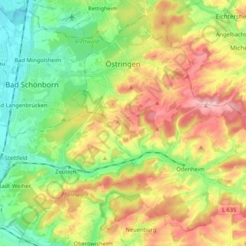
Name: Östringen topographic map, elevation, terrain.
Location: Östringen, Karlsruhe, Bade-Wurtemberg, 76684, Allemagne (49.15296 8.67759 49.23804 8.82582)
Average elevation: 178 m
Minimum elevation: 102 m
Maximum elevation: 283 m
Other topographic maps
Click on a map to view its topography, its elevation and its terrain.
Saalbach
Allemagne > Bade-Wurtemberg > Karlsruhe
Saalbach, Karlsruhe, Bade-Wurtemberg, 75053, Allemagne
Average elevation: 142 m