
Yuecheng District topographic map
Interactive map
Click on the map to display elevation.
About this map
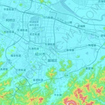
Name: Yuecheng District topographic map, elevation, terrain.
Location: Yuecheng District, Shaoxing, Zhejiang, 312000, China (29.87123 120.49684 30.13362 120.80267)
Average elevation: 45 m
Minimum elevation: -4 m
Maximum elevation: 580 m
Other topographic maps
Click on a map to view its topography, its elevation and its terrain.
Yuecheng District
China > Zhejiang > Yuecheng District
Yuecheng District, Shaoxing, Zhejiang, China
Average elevation: 180 m