
Paris topographic map
Interactive map
Click on the map to display elevation.
About this map
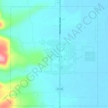
Name: Paris topographic map, elevation, terrain.
Location: Paris, Bear Lake County, Idaho, 83261, United States (42.21227 -111.42036 42.24362 -111.38607)
Average elevation: 1,831 m
Minimum elevation: 1,807 m
Maximum elevation: 1,978 m
Paris lies in a high valley of the Rocky Mountains, at nearly 6,000 feet (1,830 m) in elevation.
Other topographic maps
Click on a map to view its topography, its elevation and its terrain.
Bern
United States > Idaho > Bear Lake County
Bern, Bear Lake County, Idaho, 83220, United States
Average elevation: 1,858 m
Montpelier
United States > Idaho > Bear Lake County > Montpelier
Montpelier, Bear Lake County, Idaho, 83254, United States
Average elevation: 1,842 m
St. Charles
United States > Idaho > Bear Lake County > St. Charles
St. Charles, Bear Lake County, Idaho, 83272, United States
Average elevation: 1,830 m