
Sulthanbathery topographic map
Interactive map
Click on the map to display elevation.
About this map
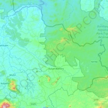
Name: Sulthanbathery topographic map, elevation, terrain.
Location: Sulthanbathery, Wayanad, Kerala, India (11.55087 76.07507 11.87263 76.44353)
Average elevation: 836 m
Minimum elevation: 693 m
Maximum elevation: 1,798 m
Other topographic maps
Click on a map to view its topography, its elevation and its terrain.
Kuruva Island
India > Kerala > Sulthanbathery
Kuruva Island, Sulthanbathery, Wayanad District, Kerala, India
Average elevation: 733 m
Kenichira
India > Kerala > Sulthanbathery
Kenichira, Sulthanbathery, Wayanad District, Kerala, 673596, India
Average elevation: 770 m
Nambikolly
India > Kerala > Sulthanbathery
Nambikolly, Sulthanbathery, Wayanad, Kerala, 673595, India
Average elevation: 873 m
Ambalavayal
India > Kerala > Sulthanbathery > Ambalavayal
Ambalavayal, Sulthanbathery, Wayanad, Kerala, 673593, India
Average elevation: 880 m
Meenangadi
India > Kerala > Sulthanbathery > Meenangadi
Meenangadi, Sulthanbathery, Wayanad, Kerala, 673591, India
Average elevation: 785 m