
Moody County topographic map
Interactive map
Click on the map to display elevation.
About this map
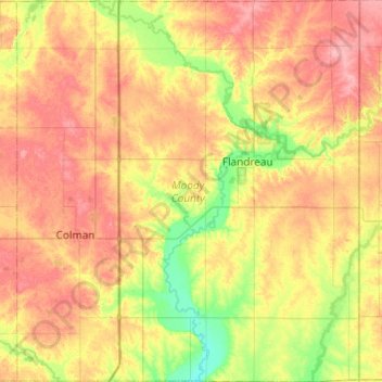
Name: Moody County topographic map, elevation, terrain.
Location: Moody County, South Dakota, USA (43.84751 -96.88882 44.19840 -96.45277)
Average elevation: 498 m
Minimum elevation: 453 m
Maximum elevation: 544 m
Other topographic maps
Click on a map to view its topography, its elevation and its terrain.
Missouri River
Missouri River, Sully County, South Dakota, 64072, USA
Average elevation: 901 m
Sisseton
USA > South Dakota > Sisseton
Sisseton, Roberts County, South Dakota, 57262, USA
Average elevation: 376 m
Angostura Recreation Area
Angostura Recreation Area, Fall River County, South Dakota, USA
Average elevation: 990 m