
Pokaran Tehsil topographic map
Interactive map
Click on the map to display elevation.
About this map
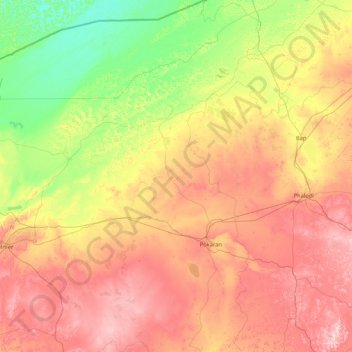
Name: Pokaran Tehsil topographic map, elevation, terrain.
Location: Pokaran Tehsil, Jaisalmer District, Rajasthan, India (26.45770 71.37470 27.95974 72.33768)
Average elevation: 206 m
Minimum elevation: 102 m
Maximum elevation: 359 m
Other topographic maps
Click on a map to view its topography, its elevation and its terrain.
Mount Abu
India > Rajasthan > Abu Road Tehsil
Mount Abu, Abu Road Tehsil, Sirohi District, Rajasthan, 307500, India
Average elevation: 914 m
Kota
India > Rajasthan > Ladpura Tehsil
Kota, Ladpura Tehsil, Kota District, Rajasthan, 324001, India
Average elevation: 286 m
Rashmi
India > Rajasthan > Deogarh Tehsil
Rashmi, Deogarh Tehsil, Rajsamand District, Rajasthan, India
Average elevation: 616 m
Aravalli Range
Aravalli Range, Abu Road Tehsil, Sirohi, Rajasthan, 307501, India
Average elevation: 1,339 m
Guru Shikhar, Abu
Guru Shikhar, Abu, Abu Road Tehsil, Sirohi, Rajasthan, 307501, India
Average elevation: 1,366 m