
Make a donation
Cape Agulhas Local Municipality topographic map
Click on the map to display elevation.
Make a donation
About this map
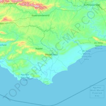
Name: Cape Agulhas Local Municipality topographic map, elevation, terrain.
Average elevation: 120 m
Minimum elevation: -1 m
Maximum elevation: 1,589 m
Make a donation
Other topographic maps
Click on a map to view its topography, its elevation and its terrain.
Suurbraak
South Africa > Western Cape > Overberg District Municipality > Swellendam Local Municipality
Average elevation: 171 m
Stormsvlei
South Africa > Western Cape > Overberg District Municipality > Swellendam Local Municipality
Average elevation: 148 m
Witklip Dam
South Africa > Western Cape > Overberg District Municipality > Theewaterskloof Local Municipality
Average elevation: 687 m
Steenboksberg
South Africa > Western Cape > Overberg District Municipality > Theewaterskloof Local Municipality
Average elevation: 469 m
Make a donation
Bredasdorp
South Africa > Western Cape > Overberg District Municipality > Cape Agulhas Local Municipality
Bredasdorp is situated at an elevation of between 40 and 120 metres (130 and 390 ft) on the slopes of the Heuningberg (Afrikaans for "Honey Mountain"). There is no significant watercourse flowing through the town, although the Kars Rivier flows past a few kilometres to the east.
Average elevation: 104 m
Arniston
South Africa > Western Cape > Overberg District Municipality > Cape Agulhas Local Municipality
Average elevation: 13 m
Kleinbaai
South Africa > Western Cape > Overberg District Municipality > Overstrand Local Municipality
Average elevation: 15 m
Napier
South Africa > Western Cape > Overberg District Municipality > Cape Agulhas Local Municipality
Average elevation: 170 m
Make a donation
Pringle Bay Peak
South Africa > Western Cape > Overberg District Municipality > Overstrand Local Municipality
Average elevation: 35 m
Boosmansbos
South Africa > Western Cape > Overberg District Municipality > Swellendam Local Municipality
Average elevation: 1,123 m
Spitskop
South Africa > Western Cape > Overberg District Municipality > Swellendam Local Municipality
Average elevation: 541 m
Danger Point Lighthouse
South Africa > Western Cape > Overberg District Municipality > Overstrand Local Municipality
Average elevation: 6 m
Make a donation
Barrydale
South Africa > Western Cape > Overberg District Municipality > Swellendam Local Municipality
Average elevation: 425 m
Skipskop
South Africa > Western Cape > Overberg District Municipality > Cape Agulhas Local Municipality
Average elevation: 10 m
Ouplaas
South Africa > Western Cape > Overberg District Municipality > Swellendam Local Municipality > Ouplaas
Average elevation: 135 m