
Kamberg topographic map
Click on the map to display elevation.
About this map
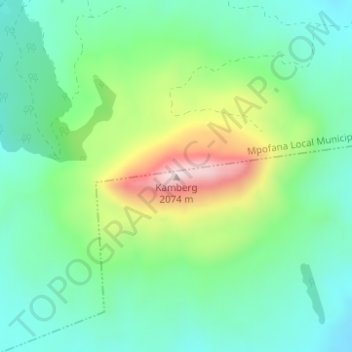
Name: Kamberg topographic map, elevation, terrain.
Average elevation: 1,768 m
Minimum elevation: 1,629 m
Maximum elevation: 2,085 m
Other topographic maps
Click on a map to view its topography, its elevation and its terrain.
uMngeni River
South Africa > KwaZulu-Natal > uMgungundlovu District Municipality > uMgeni Local Municipality
Average elevation: 850 m
Midmar Dam
South Africa > KwaZulu-Natal > uMgungundlovu District Municipality > uMgeni Local Municipality > Howick
Average elevation: 1,063 m
uMngeni
South Africa > KwaZulu-Natal > uMgungundlovu District Municipality > uMgeni Local Municipality
Average elevation: 1,083 m