
Thank you for supporting this site ❤️
Make a donation
Make a donation
Puyloubard topographic map
Click on the map to display elevation.
Thank you for supporting this site ❤️
Make a donation
Make a donation
About this map
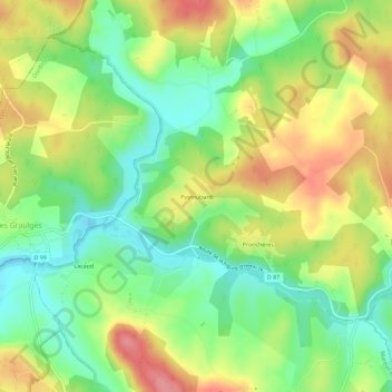
Name: Puyloubard topographic map, elevation, terrain.
Average elevation: 146 m
Minimum elevation: 103 m
Maximum elevation: 200 m
Thank you for supporting this site ❤️
Make a donation
Make a donation
Other topographic maps
Click on a map to view its topography, its elevation and its terrain.
Les Graulges
France > Nouvelle-Aquitaine > Dordogne > Mareuil en Périgord
Le bourg est implanté à 145 m d'altitude, sur une hauteur dominant la vallée de la Nizonne qui fait la limite sud de la commune.
Average elevation: 140 m