
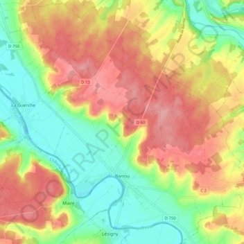
Barrou topographic map
Interactive map
Click on the map to display elevation.
About this map
Name: Barrou topographic map, elevation, terrain.
Average elevation: 99 m
Minimum elevation: 46 m
Maximum elevation: 151 m
Other topographic maps
Click on a map to view its topography, its elevation and its terrain.
Rouziers-de-Touraine
Frankrijk > Centre-Val de Loire > Indre-et-Loire
Rouziers-de-Touraine, Chinon, Indre-et-Loire, Centre-Val de Loire, Metropolitaans Frankrijk, 37360, Frankrijk
Average elevation: 116 m
Cour
Frankrijk > Centre-Val de Loire > Indre-et-Loire > Orbigny
Cour, Orbigny, Loches, Indre-et-Loire, Centre-Val de Loire, Metropolitaans Frankrijk, 37460, Frankrijk
Average elevation: 137 m
Orbigny
Frankrijk > Centre-Val de Loire > Indre-et-Loire
Orbigny, Loches, Indre-et-Loire, Centre-Val de Loire, Metropolitaans Frankrijk, 37460, Frankrijk
Average elevation: 140 m
Amboise
Frankrijk > Centre-Val de Loire > Indre-et-Loire
Amboise, Loches, Indre-et-Loire, Centre-Val de Loire, Metropolitaans Frankrijk, 37400, Frankrijk
Average elevation: 91 m
Chemillé-sur-Indrois
Frankrijk > Centre-Val de Loire > Indre-et-Loire
Chemillé-sur-Indrois, Loches, Indre-et-Loire, Centre-Val de Loire, Metropolitaans Frankrijk, 37460, Frankrijk
Average elevation: 120 m
Villeloin-Coulangé
Frankrijk > Centre-Val de Loire > Indre-et-Loire
Villeloin-Coulangé, Loches, Indre-et-Loire, Centre-Val de Loire, Metropolitaans Frankrijk, 37460, Frankrijk
Average elevation: 125 m
Les Crèmes
Frankrijk > Centre-Val de Loire > Indre-et-Loire > Beaulieu-lès-Loches
Les Crèmes, Beaulieu-lès-Loches, Loches, Indre-et-Loire, Centre-Val de Loire, Metropolitaans Frankrijk, 37600, Frankrijk
Average elevation: 96 m
Le Bourg
Frankrijk > Centre-Val de Loire > Indre-et-Loire > Artannes-sur-Indre
Le Bourg, Artannes-sur-Indre, Arrondissement de Tours, Indre-et-Loire, Centre-Val de Loire, Metropolitaans Frankrijk, 37260, Frankrijk
Average elevation: 73 m
Chaveignes
Frankrijk > Centre-Val de Loire > Indre-et-Loire
Chaveignes, Chinon, Indre-et-Loire, Centre-Val de Loire, Metropolitaans Frankrijk, 37120, Frankrijk
Average elevation: 73 m
Richelieu
Frankrijk > Centre-Val de Loire > Indre-et-Loire
Richelieu, Chinon, Indre-et-Loire, Centre-Val de Loire, Metropolitaans Frankrijk, 37120, Frankrijk
Average elevation: 59 m
Tours (Indre-et-Loire)
Frankrijk > Centre-Val de Loire > Indre-et-Loire > Tours (Indre-et-Loire)
Tours (Indre-et-Loire), Tours, Indre-et-Loire, Centre-Val de Loire, Metropolitaans Frankrijk, 37000, Frankrijk
Average elevation: 91 m
Les Ansaults
Frankrijk > Centre-Val de Loire > Indre-et-Loire > Artannes-sur-Indre > Les Ansaults
Les Ansaults, Artannes-sur-Indre, Tours, Indre-et-Loire, Centre-Val de Loire, Metropolitaans Frankrijk, 37260, Frankrijk
Average elevation: 73 m
Jaulnay
Frankrijk > Centre-Val de Loire > Indre-et-Loire > Jaulnay
Jaulnay, Chinon, Indre-et-Loire, Centre-Val de Loire, Metropolitaans Frankrijk, 37120, Frankrijk
Average elevation: 97 m
Sainte-Catherine-de-Fierbois
Frankrijk > Centre-Val de Loire > Indre-et-Loire
Sainte-Catherine-de-Fierbois, Tours, Indre-et-Loire, Centre-Val de Loire, Metropolitaans Frankrijk, 37800, Frankrijk
Average elevation: 114 m