
Thank you for supporting this site ❤️
Make a donation
Make a donation
Greußen topographic map
Click on the map to display elevation.
Thank you for supporting this site ❤️
Make a donation
Make a donation
About this map
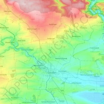
Name: Greußen topographic map, elevation, terrain.
Location: Greußen, Kyffhäuserkreis, Thuringia, Germany (51.19959 10.78569 51.31226 11.00912)
Average elevation: 238 m
Minimum elevation: 137 m
Maximum elevation: 421 m
Thank you for supporting this site ❤️
Make a donation
Make a donation
Other topographic maps
Click on a map to view its topography, its elevation and its terrain.
Unterburg
Germany > Thuringia > Kyffhäuserkreis > Kyffhäuserland > Kohlstätte
Average elevation: 301 m