

Make a donation
Bangkok topographic map
Click on the map to display elevation.
Make a donation
Bangkok
Bangkok is situated in the Chao Phraya River delta in Thailand's central plain. The river meanders through the city in a southerly direction, emptying into the Gulf of Thailand approximately 25 kilometres (16 mi) south of city centre. The area is flat and low-lying, with an average elevation of 1.5 metres (4 ft 11 in) above sea level. Most of the area was originally swampland, which was gradually drained and irrigated for agriculture by the construction of canals (khlong) which took place from the 16th to 19th centuries. The course of the river as it flows through Bangkok has been modified by the construction of several shortcut canals.
Make a donation
About this map
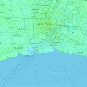
Name: Bangkok topographic map, elevation, terrain.
Location: Bangkok, Thailand (13.21910 100.32788 13.95517 100.93860)
Average elevation: 2 m
Minimum elevation: -8 m
Maximum elevation: 37 m
Make a donation
Other topographic maps
Click on a map to view its topography, its elevation and its terrain.

Chiang Mai
Thailand > Chiang Mai Province
Chiang Mai has a tropical savanna climate (Köppen Aw), tempered by the low latitude and moderate elevation, with warm to hot weather year-round, though nighttime conditions during the dry season can be cool and much lower than daytime highs. The maximum temperature ever recorded was 42.5 °C (108.5 °F) in…
Average elevation: 424 m


Make a donation